
Designed & maintained by Carol Gingell

© C.Gingell 2006-
© Broadland Memories 2006-


 1970s History
1970s Memories
1970s History
1970s Memories
1970s Photo Gallery
The next collection of photographs were taken by John Chesney and date from the mid to late 1970s. Sadly, John passed away in July 2010, but his wife Joyce sent me a large collection of the wonderful photographs he had taken of Broadland over many years of boating holidays. John and Joyce first visited the Broads in 1967 aboard the wooden motor cruiser “Cumulus” from Johnson's yard at St. Olaves. A lifelong love of Broadland began on that trip and, over the years, they revisited over 70 times on various cruisers. John was a keen photographer who developed and printed all of the photographs seen here himself, and the collection provides a wonderful record of the Norfolk and Suffolk broads during this era.
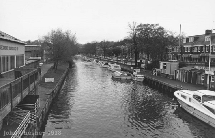
Norwich Yacht Station, photographed from Foundry Bridge in October 1978 -
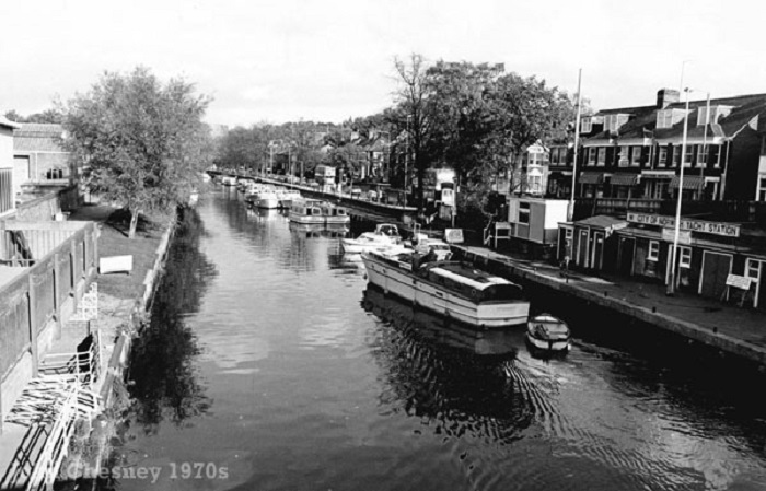
Another view of Norwich yacht Station from the late 1970s, this time a little earlier in the season, where the boats can be seen double moored up ahead.

The view from the moorings at Norwich Yacht Station, looking up towards Bishops Bridge, also pictured in the late 1970s. In the foreground is G804 “San Remo 2” which was hired from Johnsons of St. Olaves. “San Remo” was a Mk 2 Hampton Safari which went on to become “Lochmore” with Moore & Co at Wroxham before being sold to a private owner in the 1990s.

Heading upstream towards Foundry Bridge on the River Wensum -

A view of the riverside area of Norwich which has changed dramatically in recent years! Looking downstream towards Carrow Bridge, on the left was the engineering works of Boulton & Paul and in the foreground on the right was Moys coal yard. In the distance, on the right, you can see the buildings of R.J. Reads Flour Mill which originally began life as the Albion Yarn Mill. Reads moved their business to the site in the 1930s and large quantities of grain were regularly delivered by river. Closing in 1993, the buildings spent the next ten years or so becoming ever more derelict until the site was sold and work began in 2005 to redevelop the former mill and surrounding land into the massive “Reads Mill” apartment complex which we see here today.

Another view of R.J. Reads Flour Mills from the late 1970s. The Novi Sad swing bridge, which opened to pedestrians and cyclists in November 2001, now crosses the river at roughly the same point where the coaster “Siri Maria” can be seen moored above. You can compare the modern view with this one in the Norwich section of “Then & Now” photographs within the Broadland Memories archive.
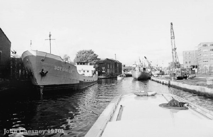
Looking upstream from a similar location to the last photograph. The coaster “Bokanier”, seen on the left, was moored beside Moys coal depot with Boulton & Paul’s engineering works on the right. From humble beginnings as an ironmongery shop in Cockey Lane in Norwich which was set up by William Moore, Boulton & Paul went on to produce a vast range of products including agricultural implements and buildings, fencing, gates, electric generators, kitchen ranges, conservatories, glasshouses, sheds, garages and summerhouses, and a range of sectional buildings and bungalows, some of which can still be found around Broadland. The riverside works closed in 1986 and in the 1990s the site was cleared and the riverside retail park and the Wherry Road housing development were built in it’s place. Once again, a modern comparison photograph of this view can be found in the Then & Now section of the website.

A little further upstream, just beyond where the Novi Sad bridge now crosses the river, approaching the Ferry Boat Inn and ABC Wharf on the left, with Boulton & Paul’s seen once again on the right. The Dutch barge seen moored on the left was the “Gestetner”. Looking at this view today you would see the Wherry Road housing development on the right and, in the distance, the Lady Julian footbridge. This photograph also features in the Norwich section of the Then & Now pages of the website.
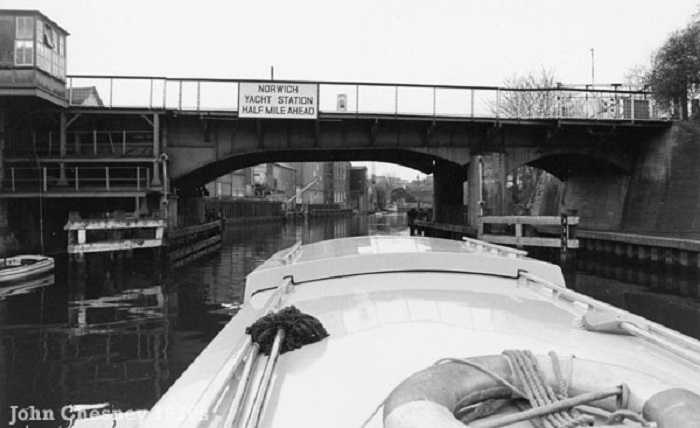
Carrow Road Bridge pictured in the late 1970s. The bridge was designed by A.E. Collins who was the city engineer and was built by J.Butler & Co. of Leeds and was actually the third Carrow Bridge, the first having been built c1810. The current, single-

This is the old Norwich power station which stood on the riverbank, roughly opposite Whitlingham Country Park, looking downstream and photographed immediately after passing beneath Trowse rail bridge. The power station was opened in 1926 after the original station in Duke Street in Norwich had reached full capacity. The coal which was needed to power the station was transported to the site by river on some of the large coasters which were once a regular site on the Yare and the Wesum. I haven’t been able to pinpoint an exact date when the station was demolished, but I believe it was during the 1980s. The wherry yacht “Olive” can be seen heading downstream. Again, this photograph is featured in the Then & Now section of the website with a modern comparison view.

A diesel train crosses the rail bridge at the west end of Thorpe St. Andrew on the River Yare, pictured by John Chesney in 1975. The rail bridges at Thorpe St. Andrew were originally built as part of the Norwich and Yarmouth Railway which opened in May 1844, engineered by George and Robert Stephenson. This line became part of the Great Eastern Railway Company in 1904, and then part of the London and North Eastern Railway in 1923. In crossing the River yare at Thorpe, the low, fixed rail bridges were obviously going to become a serious navigational hazard for river traffic coming in and out of Norwich and so a new cut was dug to bypass Thorpe Green, thus creating what we now know as Thorpe Island. The first bridges were built of timber and the line was single track. In the early 1870s, the track was widened to become double track, and the nearby Whitlingham station was built. The current rail bridges were constructed by the LNER which was formed after the railways company’s grouped together in 1923.
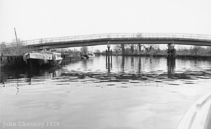
Photographed during the spring of 1979, this is the bridge at Thorpe St. Andrew which was constructed by the Jenner’s boatyard during their expansion in the late 1960s. At that time the yards of Ward’s, Jenner’s and Hearts were almost operating as one yard, the bridge was to provide a means of getting customers over the river to the island. Shortly after the bridge was built, Jenner’s was taken over by the Caister Group who redistributed the fleet and closed down the yard at Thorpe. The land where the yard once stood was re-
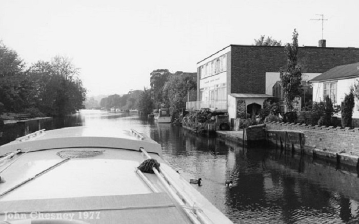
Heading upstream towards the west rail bridge, this photograph which dates from 1977 shows the Foundry House Hotel which was operated in conjunction with the Santa Lucia Hotel next door. On the far side of it is the River Garden public house. Early 20th century photos of Santa Lucia reveal why this later addition was given its name -
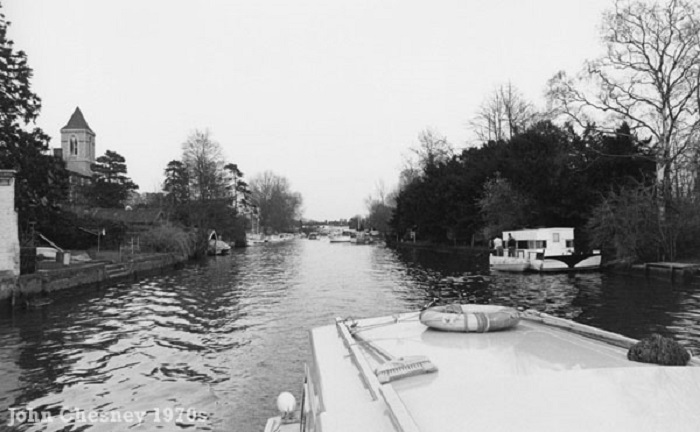
Another photo taken at Thorpe St. Andrew in the late 1970s by John Chesney. Heading downstream towards the green, on the left you can see the tower of St. Andrew’s church. Built in the 1860s to house a growing population, it replaced the medieval church which stood on the same site. Whilst most of that original church was demolished, the original tower remains and now acts as a gatehouse for the Victorian church. Early 20th century photographs show the tower as having an ornate spire -

Thorpe River Green, pictured in the late 1970s. On the right are three cruisers from the Hearts fleet -
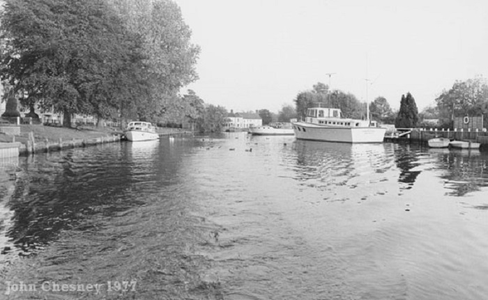
Another photograph of Thorpe Green, taken a little further downstream in 1977. In the distance you can see the Boat & Bottle public house (now the Rushcutters) and Hearts Cruisers boatyard. The large vessel seen moored on the right was “Morning Flight”, an ex military motor gun boat MGB56 which became the home to Commander Ron Ashby when he invested in Hearts Cruisers in 1948. By the early 1970s the yard was under the ownership of the Ladbrokes Group.
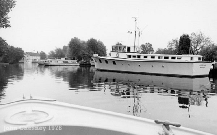
Dating from 1978, another photograph which shows the ex MGB “Morning Flight”, Hearts Cruisers and the Boat & Bottle public house at Thorpe St Andrew.

Another view of the Hearts Cruisers boatyard at Thorpe St. Andrew, taken by John Chesney in 1977. As previously mentioned, the yard was under the ownership of the Ladbrokes Group at this time, and was later sold to the Richardson Group. The cruiser in the foreground has the registration number B689 and looks to be another centre cockpit Elysian 27, so presumably another of the “Mistress of Hearts” class. Behind that is F844 “Leopardess of Hearts” which was an Aquafibre 38. This image is another which can be found with a modern comparison photograph of the same view in the Thorpe St. Andrew section of the Then & Now pages.

Another view of the Hearts Cruisers boatyard at Thorpe St. Andrew, taken by John Chesney in 1977. As previously mentioned, the yard was under the ownership of the Ladbrokes Group at this time, and was later sold to the Richardson Group. The cruiser in the foreground has the registration number B689 and looks to be another centre cockpit Elysian 27, so presumably another of the “Mistress of Hearts” class. Behind that is F844 “Leopardess of Hearts” which was an Aquafibre 38. This image is another which can be found with a modern comparison photograph of the same view in the Thorpe St. Andrew section of the Then & Now pages.

Moving further downstream on the River Yare this photograph, dating from 1978, shows the old boatyard on Whitlingham Reach at Thorpe St. Andrew. This site is now better known as the home to the Broads Authority work barges (formerly occupied by May Gurney).

Another view of the boatyard on Whitlingham Reach, photographed at the same time as the previous image. A large, sea-

The “Decca Mariner” pictured at Whitlingham Reach, Thorpe St. Andrew in the late 1970s.

More sea-
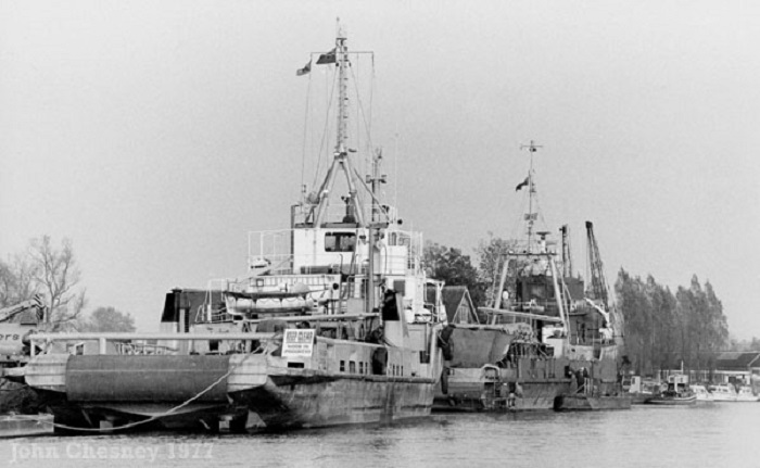
The final photograph of the boatyard at Whitlingham Reach, Thorpe St. Andrew dates from 1977.

This wreck was photographed on the River Yare by John Chesney in 1977. My thanks got to Vaughan Ashby for providing an identification of the vessel of which he says: “She was not a wherry but a genuine Thames spritsail barge. These were often seen coming up to Norwich with coastal trade up until the end of the 50′s and I can remember seeing their masts going by behind the railway line, from the gunboat Morning Flight in Thorpe. She is sunk in the old Whitlingham sewage works dyke, on the west bank of the Yare between Postwick Grove and the Woods End. She was named HAROLD MARGETTS and her registered port was ROCHESTER. You can see the remains of these two words on her transom. There was also a large wherry sunk in the dyke up ahead of her, but I don’t know her name. I used to walk over the decks of these wrecks as a boy, when there was a lot more left of them.”